| home previous page |
NORLEX |  |
| home previous page |
NORLEX | |
Sandstone members have not been formally defined, although rare, isolated, sand units have been identified at Barremian and Hauterivian stratigraphic levels and are predicted to be more widespread in the largely un-drilled deeper sections of the Vřring Basin. The following account concentrates on providing some useful additional information on the stratigraphic and geographic distribution of the formation.
Derivatio nominis: From the Norwegian word for the fish species Pollachius pallachius or Pollack (Dalland et al., 1988).
Reference well 6407/1-2: 3 slides covering the interval 3520 m - 3526 m including 2 slides from swc samples at 3520.5 m and 3526 m (Stratlab and LAP preparations) deposited at the Norwegian Petroleum Directorate.
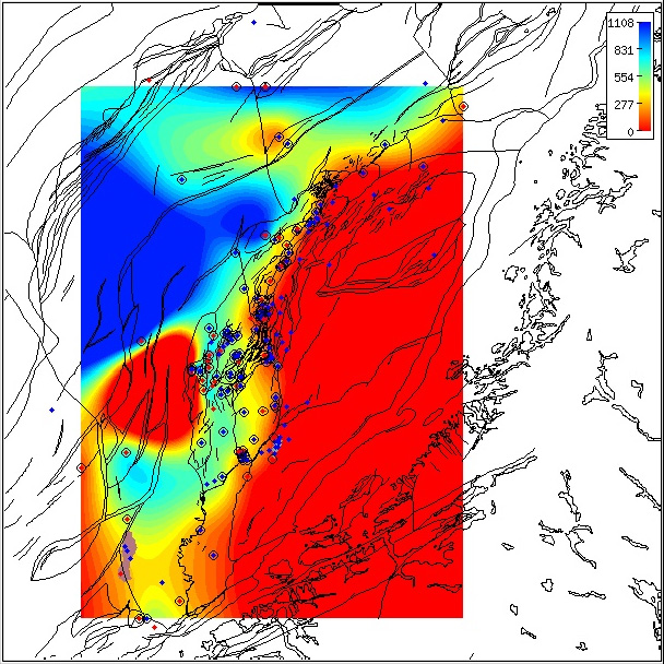
Regional isochore of the Lyr Formation thickness in the Norwegian Sea based on released well data.
The isochore map is generated from Norlex data using thin plate splines (thickness constrained to original
range).
Thicknesses in metres.
Circled wells contain both top and base horizons.
The red wells have Norlex biostratigraphy. Click for large version.
Interactive Function:
Note that this map is only a regional interpretation and the user can generate more specific, local area
isochore maps
interactively within Norlex using the link below.
|
Dalland et al. (1988) suggested that the carbonate content is expected to decrease to the west in the Mřre and Vřring Basins. The formation consists of very thin limestones with intraformational conglomerates on the eastern part of the Trřndelag Platform (Bugge et al. 1984). Dalland et al. (1988) noted a thin sequence of claystones of Hauterivian to Barremian age subcrop along the eastern part of the Trřndelag Platform. Red-brown oxidized silty claystone found there is also commonly encountered in wells further offshore. Similar sequences are exposed on Andřya and on East Greenland.
Occurrences of formation tops in wells
WGS84 coordinates: N 65°10'07.58, E 06°43'44.07
UTM coordinates: 7229359.52 N 393591.68 E
UTM zone: 32
Drilling operator name: Den norske stats oljeselskap a.s. (Statoil
a.s.)
Completion date: 06.02.1985
Status: P & A
Interval of type section & thickness in type well:
3836 m - 3812.5 m, 23.5m thickness. Note that Dalland et al. (1988) indicated in an
addendum
to the report that the base of the Lyr Formation in the type well 6506/12-1 should be 3836 m
and not 3835 m as illustrated in their figure 26 in agreement with the type description.
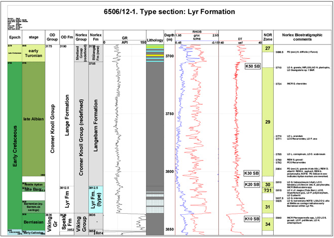
Type well 6506/12-1 (click to enlarge)
WGS84 coordinates: N 64°47'50.61, E 07°02'23.76
UTM coordinates: 7187495.23 N 406877.13 E
UTM zone: 32
Drilling operator name: Den norske stats oljeselskap a.s. (Statoil
a.s.)
Completion date: 15.05.1983
Status: P & A
Interval of type section & thickness in reference well:
3526 m - 3510 m, 16m thickness.
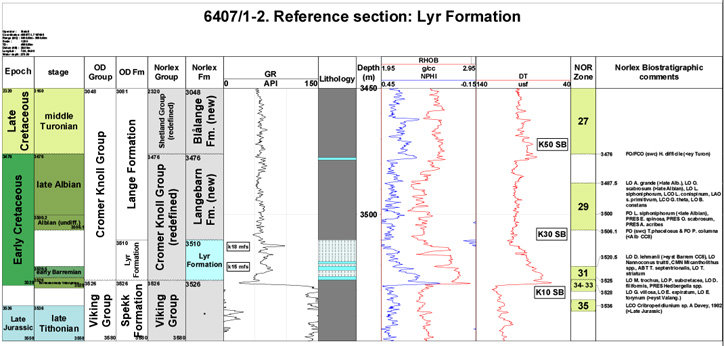
Reference well 6407/1-2 (click to enlarge)
More extensive sections of the Lyr Formation are developed in the Gimsan Basin e.g. 6407/8-1 where the base of the Cromer Knoll Group and Lyr Formation is conformable with the underlying Viking Group. In this well the Lyr Formation is over 450 m thick and contains a relatively complete sequence of Hauterivian and Valanginian dinoflagellate cysts. The base of the Lyr Formation is Early Cretaceous, latest Berriasian - earliest Valanginan age and the oldest markers recorded are the LO S. palmula and LO Endoscrinium pharo associated with an influx of pyritised radiolarians.
Following Gradstein et al. (2004) and the Time Scale Creator (TSC) database the Ryazanian Boreal Stage is partly equivalent to the Valanginian and Berriasian Stages. The revised age differs only slightly from the Valanginian - early Aptian age recorded by Dalland et al. (1988).
In addition, Smelror et al. (2001) described some shallow cores of Middle Jurassic- Early Cretaceous age from the Troms III (Harstad Basin) and Nordland VII offshore areas, northern Norway, and correlated these with the Andřya section. Using the lithostratigraphic scheme devised for the Tromsřflaket, western Barents Sea by Worsley et al. (1988), they assigned the Valanginian - Albian cored sediments to the Klippfisk and Kolje Formations. They noted the condensed calcareous siltstones and nodular limestones of the Klippfisk Formation (Valanginian - Hauterivian age) in core 6814/04-U-02 resemble those of the Lyr Formation. These were interpreted as being deposited over a long time span in a marine environment below wave base. The overlying restricted marine dark-grey pyritic claystones of the Kolje Formation (middle Hauterivian - early Albian age) penetrated in the 7018/07-U-01 and 7018/05-U-01 shallow cores (Troms III) are equivalent to the Skarstein Formation of Andřya and the Lyr and 'lowermost' Langebarn Formations of the deeper Norwegian Sea.
Dalland et al. (1988) correlated the Lyr Formation regionally with the Valhall Formation in the North Sea. Biostratigraphic calibrations in this study suggest that it is equivalent to the Ĺsgard, Mime and (lower) Sola Formations in the Viking Graben, northern North Sea and Knurr and Kolje Formations in the Barents Sea area.
Dalland, A.1975. The Mesozoic rocks of Andřy, northern Norway. Norges Geol. Unders., 316, 271-287.
Dalland, A. 1979. The sedimentary sequences of Andřy, northern Norway - deposition and structural history. Norwegian Sea Symposium, Norwegian Petroleum Society, Tromsř, 26, 1- 30.
Dalland, A. 1981. Mesozoic sedimentary succession at Andřy, northern Norway, and relation to structural development of the north Atlantic area. Canadian Society of Petroleum Geologists Memoir, 7, 563-584.
Dalland, A., Worsley, D. and Ofstad, K. 1988. A lithostratigraphic scheme for the Mesozoic and Cenozoic succession offshore Mid and Northern Norway. Bulletin of the Norwegian Petroleum Directorate, Bulletin No. 4, 1-65.
Hastings, D. S. (1987). Sand-prone facies in the Cretaceous of Mid-Norway. In: Brooks, J. and Glennie, K. (eds). Petroleum Geology of North West Europe, Graham and Trotman, 1065-1078.
Fćrseth, R. and Lien, T. 2002 Cretaceous evolution in the Norwegian Sea - a period characterized by tectonic quiescence. Marine and Petroleum Geology, 19, 1005 -1027.
Gradstein, F., Kaminski, M.A. and Agterberg, F.P. 1999. Biostratigraphy and paleoceanography of the Cretaceous seaway between Norway and Greenland. Earth-Science Reviews, 46, 27-98.
Gradstein, F., Ogg, J. and Smith, a. 2004 A Geologic Time Scale 2004. Cambridge University Press. 589 pages.
Hastings, D. S. (1987). Sand-prone facies in the Cretaceous of Mid-Norway. In: Brooks, J. and Glennie, K. (eds). Petroleum Geology of North West Europe, Graham and Trotman, 1065-1078.
Lřfaldi, M. and Thusu, T. 1979. Micropalaeontological studies of the Upper Jurassic and Lower Cretaceous of Andřya, Northern Norway. Palaeontology, 22, 413-425.
Smelrřr, M., Jacobsen, T., Rise, L., Skarbř, O., Verdenius, J. And Vigram, J.O. 1994. Jurassic to Cretaceous stratigraphy of shallow cores on the Mřre Basin Margin, Mid-Norway. Norsk Geologisk Tidsskrift, 74, pp. 89-107.
Smelror, M., Mřrk, A., Mřrk, M.B.E., Weiss, H. and Lřseth, H. 2001. Middle Jurassic - Lower Cretaceous transgressive - regressive sequences and facies distribution off northern Nordland and Troms, Norway. In: Martinsen, O.J. and Dreyer, T. (eds). Sedimentary environments Offshore Norway - Paleozoic to Recent. NPF Special Publication, 10, 211 - 232.
Swiecicki, T., Gibbs, P.B., Farrow, G.E. and Coward, M.P. 1998. A tectonostratigraphic framework for the Mid-Norway region. Marine and Petroleum Geology, 15, 245-276.
Vergara, L., Wreglesworth, I., Trayfoot, M., Richardsen, G. 2001. The distribution of Cretaceous and Paleocene deep-water reservoirs in the Norwegian Sea basins. Petroleum Geoscience, 7, 395-408.
Worsley, D., Johansen, R. and Kristensen, S.E. 1988. The Mesozoic and Cenozoic succession of
Tromsřflaket. pp. 42-61. In: Dalland, A., Worsley, D. and Ofstad, K. (eds). A
lithostratigraphic scheme for the Mesozoic and Cenozoic succession offshore Mid and Northern
Norway. Bulletin of the Norwegian Petroleum Directorate, Bulletin No. 4.
| home | previous page |