Cromer Knoll Group (Cromer Knollgruppen)
(Original definition in NPD Bulletin no.
5)
Name
From the Cromer Knoll buoy in the southern North
Sea. Named by Deegan & Scull (1977).
Type area
The type area is in the southern North Sea. Rhys (1974) used UK well
48/22-2 to illustrate a typical section of the group, and Deegan & Scull
(1977) used UK wells 29/25-1, 22/1-2A and 3/29-1, and Norwegian well
2/11-1. The emphasis in this paper is on the Norwegian sector and the
following Norwegian wells have been used to illustrate local developments
of the group:
2/6-2,
2/7-15,
2/11-1,
7/3-1,
17/11-2,
34/10-18,
35/3-4,
35/3-5,
31/6-3,
24/12-2
and 17/4-1;
the Danish well DK1-1 has also been used.
Thickness
The thickness of the group varies considerably since the sediments were
deposited in response to an active Late Jurassic tectonic phase. In the
Viking Graben, the Asta Graben and locally in the Central Trough the thickness
is often more than 600 m, gradually thinning towards the basin margins.
The group is 667 m thick in Norwegian well 2/11-1 and 643 m thick in
Norwegian well 17/11-1. Seismic data indicate that the group is thickest
in the Sogn Graben, where it probably reaches up to 1400 m.

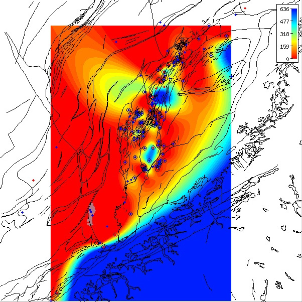
Depth to the base of the Cromer Knoll Group (revised definition) in the Norwegian Sea based on released well data.
This follows the revised definition that corresponds to the base Viking Group. The wells displayed are those that
penetrated the base of the group. Click for PDF.
|
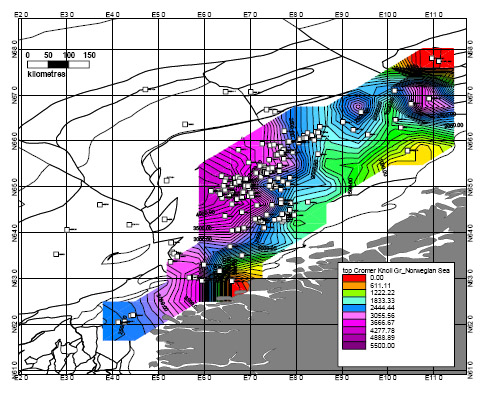
Depth to the top of the Cromer Knoll Group (revised definition) in the Norwegian Sea based on released well data.
This follows the revised definition that corresponds to the top Early Cretaceous and coincides with the North Sea
level. The wells displayed are those that penetrated the group. Click for PDF.
Interactive Norlex map of same.
|
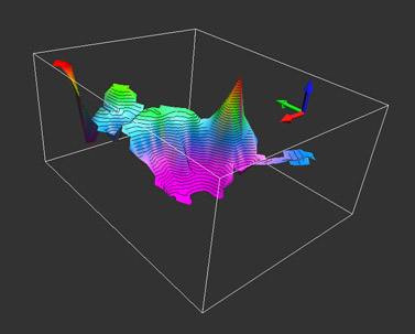
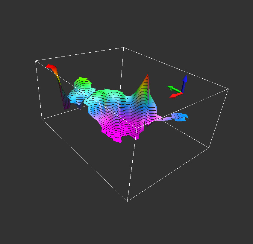
3D image of the depth to the base of the Cromer Knoll Group (revised definition) in the Norwegian Sea based on
released well data. Note that the figure is viewed from a location in the SE (Mĝre Basin) looking towards the NW
(Trĝndelags Platform). The green arrow is the North pointer.
The grid is based on the updated NorLex well data for this group and the revised NorLex
definition of the Cromer Knoll Group. Click for large version.
|
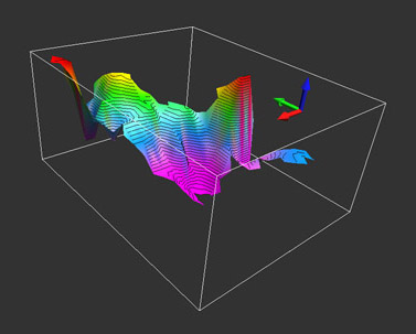
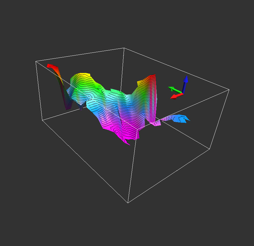
3D image of the depth to the top of the Cromer Knoll Group (revised definition) in the Norwegian Sea based on
released well data.
|
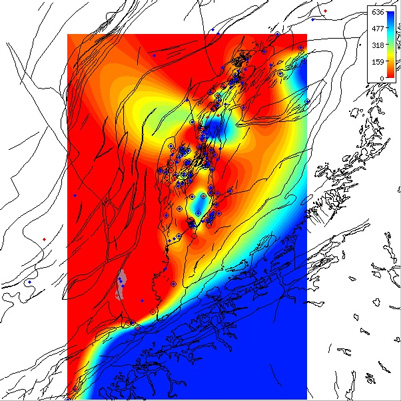
Regional isopach of the Cromer Knoll Group thickness in the Norwegian Sea based on released well data.
The group thicknesses follow the revised definition that corresponds to the top Early Cretaceous and coincides with the North
Sea level.
The isochore map is generated from Norlex data using thin plate splines (thickness constrained to original range).
Thicknesses in metres.
Circled well contain both horizons. The red wells have Norlex biostratigraphy.
Interactive Function:
Note that this map is only a regional interpretation and the user can generate more specific, local area isochore maps
interactively within Norlex using the link below.
Interactive Norlex isochore map for the Cromer Knoll Group
|
Lithology
The Cromer Knoll Group consists mainly of fine-grained, argillaceous,
marine sediments with a varying content of calcareous material. Calcareous
claystones, siltstones and marlstones dominate, but subordinate layers
of limestone and sandstone occur. The claystones are generally light to
dark grey, olive-grey, greenish and brownish, often becoming light grey,
light greenish-grey and light olive-grey marlstones. Mica, pyrite and
glauconite are common. Generally, marlstones become the more dominant
lithology in both the upper and lower parts of the group.
Logs of reference well 6506/12-1, former stratigraphic extent
Logs of reference well 6506/12-1, redefined extent
Logs of reference well 6506/12-4, former stratigraphic extent
Logs of reference well 6506/12-4, redefined extent
Basal stratotype
The lower boundary is usually well defined and is recognised by a
distinct decrease in gamma-ray response and an increase in velocity when
passing upward from the generally more organic-rich shales of the underlying
Upper Jurassic formations (Figs. 12-14 and 22).
Characteristics of the upper boundary
South of approximately 59° N (Fig. 32a), the upper boundary is the base
of the chalk facies of the Shetland Group, defined
by the onset of a decrease in gamma-ray response and an increase in velocity
into the overlying carbonates (Figs. 12-15 and 22-28). The uppermost
Rĝdby Formation of the Cromer Knoll Group often appears
on logs as a transition between the overlying carbonates of the Shetland
Group and the more argillaceous parts of the Cromer Knoll Group (Figs. 12
and 22). Further north, the upper boundary is the base of the siliclastic
facies of the Shetland Group (Fig. 32a). This boundary is normally also
shown by a decrease in gamma-ray response and an increase in velocity when
passing into the overlying, generally more calcareous,
Svarte Formation of the Shetland Group
(Figs. 33 and 36). However, the opposite log response at the boundary is
also observed (Fig. 37).
Distribution
The group is widely distributed in the Norwegian sector of the North Sea.
It is absent from the highest parts of the Mandal High, Jĉren High, Utsira
High and Lomre Terrace in the Troll area and locally from the Tampen Spur.
(Figs. 7-11).
Occurrences of group tops in wells
Age
Ryazanian (usually late) to Albian/Early Cenomanian.
Depositional environment
Open marine, with generally low energy.
Subdivision
Six formations are defined within the group in the Norwegian sector
(Figs. 7-11): the Ċsgard (new),
Tuxen (Jensen et al. 1986), Mime
(new), Sola (Hamar & Hesjedal 1983; Jensen et al. 1986),
Rĝdby and Agat (new) Formations.
In addition we recognise a need to introduce the Ran
sandstone units (new) (Figs. 7-11). Fig. 4 shows an idealised development
of the Cromer Knoll Group in the northern and central North Sea.
Remarks
The group was erected by Rhys (1974) to embrace three marine, arenaceous,
argillaceous to marly formations of mainly Early Cretaceous age recognisable
onshore and offshore. Deegan & Scull (1977) formally defined the group to
include the sediments between the underlying Humber Group and Bream
Formation and the overlying Shetland and Chalk Groups. Vollset & Dor6 (1984)
replaced the Humber Group of the northern North Sea by the
Viking Group, and the Bream Formation in the Central Trough and the
Norwegian-Danish Basin by the Tyne and
Boknfjorden Groups, respectively. The tops of the
Draupne Formation of the Viking Group, the
Mandal Formation of the Tyne Group and the
Flekkefjord Formation of the Boknfjorden Group
define the base of the Cromer Knoll Group.
The Cromer Knoll Group is partly equivalent to the Rijnland Group of the
Dutch sector (NAM & RGD 1980, Crittenden 1982) and the Speeton Clay
Formation together with the Red Chalk Formation of the UK sector
(Rhys 1974). The subdivision in this paper can be used for the Danish
sector (see also Jensen et al. 1986).