| home previous page |
NORLEX |  |
| home previous page |
NORLEX | |
Sandstones within the redefined Lange Formation are generally rare, although a sandstone unit is discussed informally that was penetrated in well 6507/7-12. This was informally described as 'Aptian Sands' by the Operator in a Lower Cretaceous mini-basin drilled in the hanging wall of the Revfallet Fault complex separating the Dřnna Terrace from the Nordland Ridge/Trřndelags Platform. This is an indication that sandstones may be developed in this formation in the deeper, undrilled parts of the Vřring Basin.
Derivatio nominis: The name Langebarn is derived from the Norwegian for the fish species Lumpenus lumpretaeformis, or more correctly, the Langhalet Langebarn or Snakeblenny. This fish is found along the entire Norwegian coast and is usually associated with muddy bottoms at 30-200 m water depths.
An informal sandstone unit in the well 6507/7-12 (3670-3703.5 mMD and 33.5 m thickness) consists of sandstones and interbedded siltstones and mudstones. The sandstones are medium grey to dark grey, white to light yellowish grey, clear quartz grains, very fine to coarse, predominantly fine to medium, becoming very silty, grading to siltstone, subangular to subrounded, occasionally angular in coarse fraction, moderately sorted, friable, argillaceous matrix, common silica cement or locally moderate calcareous cement, locally trace of coal, mica and pyrite, rare glauconite, no visible porosity. The siltstones are dark grey, blocky, firm, slightly calcareous, argillaceous grading to mudstones in part, locally very fine sandy, grading to silty sandstones, carbonaceous. The mudstones are grey, black to olive black, blocky, sub-fissile, moderately hard to hard, non calcareous becoming locally very silty, carbonaceous to very carbonaceous.
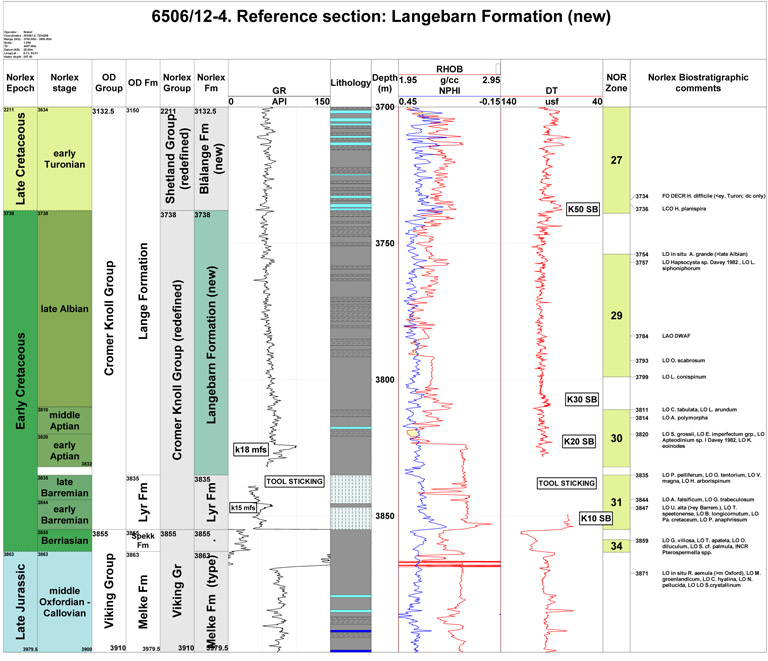
Reference well 6506/12-4: 11 slides from dc samples covering the interval 3757 m - 3835 m (Stratlab and RRI preparations) deposited at the Norwegian Petroleum Directorate.
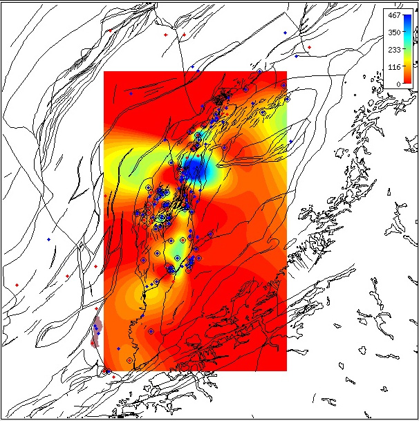
Regional isochore of the Langeabarn Formation thickness in the Norwegian Sea based on released well data.
The isochore map is generated from Norlex data using thin plate splines (thickness constrained to original
range).
Thicknesses in metres.
Circled wells contain both top and base horizons.
The red wells have Norlex biostratigraphy. Click for large version.
Interactive Function:
Note that this map is only a regional interpretation and the user can generate more specific, local area
isochore maps
interactively within Norlex using the link below.
|
Occurrences of formation tops in wells
WGS84 coordinates: N 65°10'07.58, E 06°43'44.07
UTM coordinates: 7229359.52 N 393591.68 E
UTM zone: 32
Drilling operator name: Den norske stats oljeselskap a.s. (Statoil
a.s.)
Completion date: 06.02.1985
Status: P & A
Interval of type section & thickness in type well:
3812.5 m - 3705 m, 107.5m thickness.
The lower boundary follows the original definition of Dalland et al. (1988). Previously, the
original Lange
Formation extended from 3190 m. The interval 3705 m to 3190 m is now assigned as the new formation:
Blĺlange Formation.
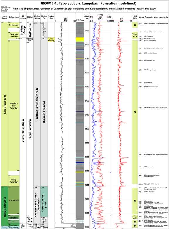 Type well 6506/12-1, with former definition of Lange Fm. (click to enlarge) |
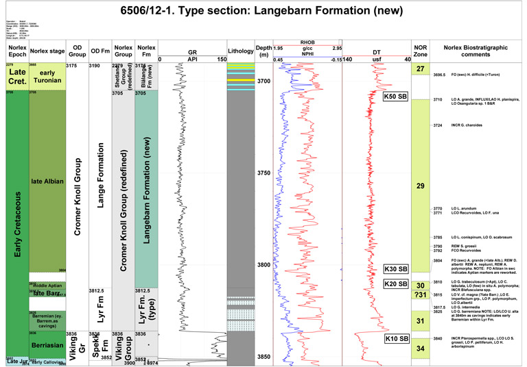 Type well 6506/12-1 (click to enlarge) |
Well name: 6506/12-4
WGS84 coordinates: N 65°12'46.97, E 06°43'30.37
UTM coordinates: 7234298.14 N 393591.29 E
UTM zone: 32
Drilling operator name: Den norske stats oljeselskap a.s. (Statoil
a.s.)
Completion date: 13.08.1985
Status: P & A
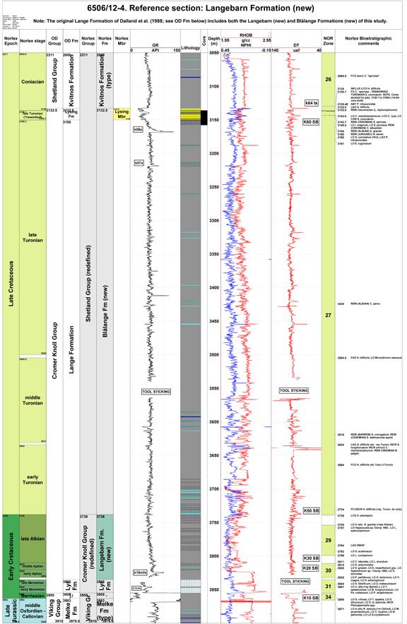
Interval of type section & thickness in reference well:
3835 m to 3738 m, 97 m thickness. The lower boundary follows the
original definition for the Lange Formation of Dalland et al.
(1988). The upper boundary of the Langebarn Formation is with the
new Blĺlange Formation.
It is unfortunate that Dalland et al. (1988) defined the 6506/12-4
as the reference section for the Lange Formation as the base of the formation
with the underlying Lyr Formation has an incomplete
log profile (on both
gamma ray and sonic logs) due to the tool sticking during wireline logging
(see figure).
 Reference well 6506/12-4, with former definition of Lange Fm. (click to enlarge) |
 Reference well 6506/12-4 (click to enlarge) |
In the type and reference wells, the upper boundary with that of the overlying Blĺlange Formation is associated with the late Albian dinocyst LO Apteodinium grande and the planktonic foraminiferal event LAO Hedbergella planispira. In these wells Cenomanian sediments (Zone 28) of the basal Blĺlange Formation are absent.
In the 6507/7-12 well, an informal unit of interbedded sandstones and mudstones developed between 3670-3703.5 mMD and informally referred to as 'Aptian Sands' by Conoco (operator) is dated between the LO Achmosphaera neptuni (3600 m) of middle Aptian age and LO Sirmodinium grossii (3750 m) of early Aptian age, establishing firmly that the member is middle Aptian age (Zone 30).
Dalland et al. (1988) had the oldest extent of their Lange Formation as ranging into the Ryazanian Boreal stage and as a partial time equivalent of the Lyr Formation which they considered to be Valanginian to early Aptian. This interpretation is not followed in this study with the oldest extent of the Langebarn Formation being stratigraphically younger than the Lyr Formation.
It is noteworthy that Lower Cretaceous sandstones of the Langebarn and Lyr Formations do not represent any appreciable thickness and are exceptionally rare in the Norwegian Sea based on the available released well coverage. This may be due to the Lower Cretaceous interval being generally not reached in wells drilled in the Vřring Basin. In addition, the wells drilled at the margins of the Trřndelags Platform are typically on structurally high Cretaceous locations in the quest for target deeper, Jurassic prospects. The frequency and distribution of Lower Cretaceous sandstones analogous to the North Sea Agat Member is therefore considered to be underestimated based on the available well data. The (informally retained) sandstones penetrated in well 6507/7-12 represent the best example drilled to date of these potentially more extensive Lower Cretaceous sandstones.
Dalland, A., Worsley, D. and Ofstad, K. 1988. A lithostratigraphic scheme for the Mesozoic and Cenozoic succession offshore Mid and Northern Norway. Bulletin of the Norwegian Petroleum Directorate, Bulletin No. 4, 1-65.
Fćrseth, R. and Lien, T. 2002. Cretaceous evolution in the Norwegian Sea - a period characterized by tectonic quiescence. Marine and Petroleum Geology, 19, 1005 -1027.
Gradstein, F., Kaminski, M.A. and Agterberg, F.P. 1999. Biostratigraphy and paleoceanography of the Cretaceous seaway between Norway and Greenland. Earth-Science Reviews, 46, 27-98.
Swiecicki, T., Gibbs, P.B., Farrow, G.E. and Coward, M.P. 1998. A tectonostratigraphic framework for the Mid-Norway region. Marine and Petroleum Geology, 15, 245-276.
Vergara, L., Wreglesworth, I., Trayfoot, M., Richardsen, G. 2001. The distribution of Cretaceous and
Paleocene deep-water reservoirs in the Norwegian Sea basins. Petroleum Geoscience, 7, 395-408.
| home | previous page |